|
GEOLOGICAL
TOURS:
1-
Geological Tour through the Karakuram Highway:
GEOLOGICAL
TOUR THROUGH THE KARAKORAM HIGHWAY
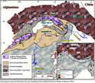
Geologically
this part of the Pakistan has two major sutures (places
where two continents weld together), the Shyoyok Suture
and Indus Suture that mark the closing of Tethys and the
collision of the Indo-Pakistan plate with collage of plates
that make up Asia. The situation is made more interesting
by the fact that an Island arc (Kohistan) is sandwiched
between two continentals plates and the whole crust of the
arc is exposed. Since collision, mountain building process
have been operative and are still going on both in Himalayas
to the south and in the Karakuram in the north, the geological
processes involved in collision of the continental plates.
KKH
provides excellent opportunity to see at least four different
tectonic terrains, crust of Indo-Pakistan plate, suture
zones, an island arc (Kohistan) and Ksarakoram plate. So
traveling on KKH from south to north, from Islamabad to
Hunza covers sequence on Indo-Pakistan plate can be seen
first. While the basement rocks can be best seen in Manshera
and Besham areas. North of Besham near Jijal, suture (MMT,
Main Mantle Thrust) between Indo-Pakistan plat and Kohistan
can be seen. In Swat Valley this suture is represented by
talc carbonate schist, which is the host for gem quality
emeralds. In Kohistan the basement is represented by deep crystal
and upper mantle rock (ultramafics and garnet granulites)
of Jijal complex, followed by metavolcanics of Komila amphibolites
belt, and the Chilas complex (layered intrusion consisting
of gabbros. Norited, Choromitites and ultramfics). Volcanic
arc of Kohistan is represented by Chalt volcanic, which
is overlain by marine sediments of Yasin Group.
Both
Chalt volcanics and Yasin sediments are intruded by Kohistan
batholith. Kohkistan is separated from Karakoram by Shoyk
suture (MKT, Main Karakuram Thrust). North of Shyok suture
in Karakoram plate ruby bearing marbles can be seen.
Itinerary:
 |
|
 |
| Day-01 |
Arrival to Islamabad airport and transfer to hotel,
in the rest of time sightseeing in Islamabad, is the
capital of Pakistan, located against the backdrop of
Margalla hills at the north edge of Potohar. It is contrast
to its twin city Rawalpindi, it is lush green/visit
to Shah Faisal Mosque/ Daman-e-Koh, this low hill overlooking
Islamabad known as a Daman-e-Koh, offer panoramic view
of Islamabad/Lok Virsa (National Institute of folk and
Tradition Haritage. You may visit to Rawalpindi, old
Bazaar. |
| Day-02 |
Proceed
to Peshawar 3-4hrs drive, en-route visit to Taxila,
is situated around 35 kilometers to the northwest of
Rawalpindi, which represents one of the most important
archaeological sites in Pakistan. This was the capital
of the rich Gandhara Buddhist civilization, which flourished
in Pakistan from at least the sixth century BC through
to the fifth century AD, evolving and changing over
the centuries as it observed the influence of various
conquering empires. Today Taxila is archaeologist's
paradise and there is well maintained museum here and
eight sights scattered around a very short radius. Amongst
the best preserve are Jualian, Dharmarajika, Jandial
and Sirikap.
Arrival to the Peshawar, the capital of Northwest Frontier
Provence (NWFP), is Pakistan most diverse province.
Peshawar is located at the elevation of 350 m from the
sea is 80 square kilometer with about 11,00,000 inhabitants.
For sightseeing in Peshawar are Museum, Mohabt Khan
Mosque and old Bazaar. The Bazaar of old City area Kaleidoscope
of colors, sound and smell, crowed of people jostle
with cars and bicycles, donkey carts and Rikshawes and
narrow alleys lead off from the main streets. Concealing
even more colorful and atmospheric bazaars with everything
from vegetables to ornate gold and silver jewelry. Some
of famous Bazaar is Khyber Bazaar, Namak Mandi, Qissa
khawani Bazaar and also Gemstone market etc. |
| Day-03 |
Excursion
to KHYBER PASS, is one of the most important and famous
passes of the world, located in the Khyber Agency. This
Pass connects Central Asia with the South Asian Sub-Continent.
This 4 kilometers long Pass starts from the foot of
the hills near Jamrud and ends at Torkham on Pakistan-Afghanistan
border. Being the shortest route to the South Asian
Sub-Continent, most of the races and invading armies
marched through this Pass. When the British invaded Afghanistan, they sent their forces along the same Pass.
Khyber Pass has a very rich history Buddhism spread
through this Pass to Afghanistan and the stupas at Ali
Masjid and Sphola bear witness to it. The Afghans against
the invading armies fought many battles here. Amir Taimur
built a prison in the Pass, which is visible from Michni
Post. Akbar the Great built a fortess at Kafirkot, near
Charbagh. The Mughal army of Aurangzeb was massacred
near Landikotal in 1672 AD. The Sikhs built a strong
fort at Jamrud where General Hari Singh Nalwa was killed
in 1837.
While
going to Khyber Pass you may see or observe most interesting
Geological sites along the road side in the Khyber carbonate complex, the Ordovician/ Silurian Landikotal
Formation overlain by with a faulted contact by a
series of shale, Quartzite, dolomite and limestone.
In the northern part it is disconnected by basic intrusion.
Some limestone beds are fossiliferous and contain
bryozoar crinoids remains. The Shagai Formation is
unfossiliferous. Ali Mastij formation extends all
over the Khyber agency. Type locality is the village
of Ali Mastij. The formation is composed of red shale,
altering with still stone, Sandstone, quartzite and
limestone, break in deposition is indicated by conglomerates
and laterites. Ali Masjid formation has fossiliterous
beds. The fossil are brachiopod and coral fauna, which
are indicative of late Devonian age.
|
| Day-04 |
Drive to Swat 5-6 hrs, a land that shines with fruite
- laden orchards, flowering filled slopes, meandering
rivers, rumbling streams and surrounded by the mighty
range of the Hindu-Kush and Karakuram. The Swat valley
is one of the most fertile and easily accessible mountainous
areas in the northern Pakistan. The main attraction is its scenic beauty and pleasant climate in the summer.
The valley is about 3250 feet/991m above the sea level.
The area is rich in historical sites dating back to
the Ganhara Buddhist period. Saidu Sharif and Mangora
is the town. En route visit to Takht-e- Bhai, small
town famous for its nearby Gandhara Buddhist monastery,
is perched striking on the side of a bare ridge of rock
rising abruptly up from the surrounding plains, and
is certainly the best preserved and most impressive
piece of Gandhara architecture in Pakistan. The sophistication
and quality of the building work is clear from the beautifully
fashioned walls and well - preserved brickwork.
In the Swat Valley, east of Mingora town the Indian
sub continent sequence is comprised of pre-Cambrian
Manglour crystalline schist which is overlain by Alpuri
talc-mica - garnet schist and the Saidu talc graphitic
schist, Paleozoic to early Mesozoic age. In this group
there is an assemblage of fragmented blocks, sheet and
lenses, drived from the oceanic crust, voleanic arcs,
trenches and continental Margins, which is pre-Cambrian
to late cerateous age.
North to South the mélange group contains three thrust
sheets in upper side is the Shangla blue schist mélange,
Middle Charbagh green schist mélange and the lower one
is Mingora ophiotite mélange, which is significant for
gem mineralization, especially for emerald. The mingora
ophiolite melange composed of talc chlorite dolomite
schist and calc-quartz-mica-chlorite schist. The emerald
mineralization is confined to the talc carbonate schist.
Overnight at the hotel in Swat Valley. |
| Day-05 |
In
the morning visit to Emerald Mines (Gujarkill emerald
mines) also visit to the Kalam Valley and back to the
Mangora for overnight |
| Day-06 |
Drive to Besham via Shangla Pass 3-4 hrs, overnight
at hotel |
| Day-07 |
Continue
to Gilgit (7-8 hrs drive) on of Karakuram Highway 8th
wounder of the world, also called " Silk Route".
We will pass through the Kohistan and Chilas to Gilgit
region. Kohistan is probably one of the most dramatic
as the road clings to the increasingly vertical sides
of the narrow Indus gorge. This is also one of the wilder
area of Pakistan, with the little government control
beyond the main highway. Kohistan means " Land
of Mountains" one of the geological facinating
places on the earth. As the Karakoram Highway follows
the course of deep Indus gorge, the rock formation takes
you on a journey from the center of earth to its outer
crust. There is suture (shear zone), MMT, Main Mantle Thrust, which separates the Kohistan from the Himalayas
Indian plate to the south and Southeast. The greenish and dark red rocks (Dunite, Wehrlite, and websterie)
along the roadside are the result of materials formed
30 kilometers below the earth surface, mantle part of
the earth. The pattern of settlement has been the occupation
of numerous small valleys where glacial streams and
rivers are more controllable as opposed to habitation
in the Indus valley itself. The mountain ranges between
these valleys proved a barrier to communication.
In this section you will study of the rocks along the roadside. In the way you may make several stops to see
the meeting point of three mountain ranges the Himalaya,
the Karakuram and the Hinud-Kush and Nanga Parbat view-point.
Gilgit the capital of Northern Areas of Pakistan located
in the heart of Karakuram range surrounded with lofty
peaks, also visit to local bazaar and Kargha Buddha.
Overnight at hotel. |
| Day-08 |
In the morning visit to the local gemstone market then
proceed to Hunza Karimabad (2-3 hrs). On the way to
Hunza (99km) the road gradually climbs approximately
every 10-km difference of 100m. You will join Karakuram
Highway from Gilgit. You will be enjoying a spectacular
view of mount Rakaposhi (7788m) having many habitants and villages around its foothills, with its snow crown
changing color with light. The route is abundant with
terraced fields, particularly apricot, apple and walnut
trees at most spectacular either in blossom or during
autumn.
We will also stop at place where continents collide,
MKT, Main Karakuram Thurst. This is the collision of
the Indo-Pak and the Eurasian plate located at the Chalt.
The point of continental collision (MKT, Main Karakuram
Thrust) is marked in these areas. The history of tectonic
evolution has very close relationship with different
period of organic movement caused by under thrust of
Indo-Pakistan (Indian) plate, north below the Eurasian
Plate. Geologically millions of years ago, now the Northern
Areas of Pakistan were submerged under a sea called
"Tethyn" between Indo-Pak and Eurasian plate.
During this collision Indo-Pak plate sub ducted under
the Eurasian plate, which is still going on, about 5
cm per year. During this organic movement Tethyn Sea
disappeared and reduced to now Arabian Sea when plates
became closed. The remain material of the sea newly
erupted material by lava formed two Island arcs, Kohistan
Island arc (Jajil to Chalt) and Ladhk Island arc some
parts of Baltistan is on Ladhk Island arc. Both plates
have now continental parts. Due to this continental
collision raise of Karakuram and Himalayas took place,
which are highest as well as youngest mountain ranges
in the world. Indo-Pak plate is still sub ducting under
the Eurasian plate. The mountain chain being squeezed
upward as the Indo-Pak plate pushes against the Eurasian
plate. The mountains are raising at an average rate
of 7 mm per year. Actually the mountains are raising highly
due to this effect the rate of denudation is
also high. In this way canon and gorges become deeper
and deeper.
Arrival to Karimabad (2500m) the capital of Hunza is
the only town in the world, where you may view five
peaks above 7000m in all four directions. The Mount
Rakaposhi 7788m Drian 7256 m, Golden peak 7027 m, Ultar
- I 7388m and Ultur-II 7310m, with princess Bobulimuting
reaches as Hunza skyline. Overnight at hotel |
| Day-09 |
In
Karimabad you will explore the Hunza Valley and neighboring,
see the daily life of hard-work people. Visit to Baltit
Fort, is former place of Mir's (Rulers) of Hunza until
1960, which is recently restored by Aga Khan Trust for
culture. And also visit 900 year old Altit Fort was
built by the people of Baltistan. When Queen of Balistan
was married to the Prince of Hunza as a presentation
they built this Fort which is on cliff of the Ruby Marble
rock.
At the evening you may walk or drive to the Duikar village
(3000m) highest point of the valley, gives majestic
view of peaks and central Nagar and Hunza valley. Overnight
at hotel |
| Day-10 |
Excursion
to the Hoper village in Nagar valley, visit to the ruby
mines and meeting with local dealers of gemstone. Roby
is found in metamorphosed crystalline marble along the main Karakuram Thurst (MKT) that traced as a belt
to the Ishkoman Valley. Presently ruby is being mined
only in Hunza Valley there are some mines scatters.
The finest red spinal and parasite occur in associated
with in ruby in the metamorphosed crystalline marble.
Robies are formed in a metamorphose limestone which
consists largely of calcite. Some of the included calcite
crystal dolomite the magnesium- calcium carbonate also
found as an inclusion, the potassium mica pholopite is also common inclusion forming bunches of reddish
brown flakes. |
| Day-11 |
Continue
to Khunjerab Pass (4733m) 3-4 hrs drive, behind the
Karimabad you will find the carving at Danydas, with
early inscription and drawing, including hunting scenes
of Ibex from early traders on the Silk Route. En route
visits to Gulmit village and Museum as well as obtains
magnificent views from the road, Passu Glacier while
touching the Karakuram Highway.
In the way you may see the contact between Karakuram
Batholith and Passu slates. Karakuram Batholith consists
of granondiorite and pegmatite and Passu slats are exposed
to the north of Karakuram Batholith.
Khunjerab Pass (4733m) the roof the world, gateway to
China and highest highway in the world. This is the
route that Marcopolo traveled 700 year ago. In Krghiz
language "Khunjerab Pass" means the valley
of
Blood the name the pass earned centuries ago from the
activities at the khanjut brigands who make the livelihood
by attacking cravens. Drive to back to Passu or Gulmit
(2-3 hr / hotel |
| Day-12 |
Proceed
to Gilgit 3-4 hrs overnight at hotel |
| Day-13 |
Continue
to Skardu 7-8hrs drive, in the way visit to Shingus
mines the northern bank of Indus. Arrival to Skardu
overnight at hotel |
| Day-14 |
Day
free in Skardu to visit the local gemstone shops and
meeting with the dealers/ sightseeing of Skardu |
| Day-15 |
Full
day excursion to Shigar Valley to visit the mines and
back to Skardu for overnight |
| Day-16 |
Fly
to Islamabad it is about one hour mountain flight gives
aireal view of the Karakuram, the Himalaya and the Hindu-
Kash mountains. It is like an air safari. Overnight at
hotel |
| Day-17 |
Full
day excursion to Murree is 65 kilometer in the northeast
of Islamabad, on the series of outline Himalayan spurs.
Lie a series of settlement that were developed by the
British as hill resorts. Back to Islamabad for overnight
at hotel |
| Day-18 |
Departure
from Islamabad drop to the airport |


|