Climbing
Mountains
The best-known attraction for the
Mountaineers is the North of Pakistan.
Northern part is in knot of four great
mountain ranges, the Himalayas, the Karakoram,
the Hindu-Kush and the Pamir with densest
concentration of high peaks on earth,
including the second highest peak, K-2
(8611M). Radiating out to the west on the
border with Afghanistan lies the HINDU-KUSH
whose eastern border is marked by the Ishkoman
and Karumber River in Gilgit District, the
eastern end of range known HINDU RAJ, means
Hindu Rule. Following north from there
the Pamir runs up into the former Soviet
Union. Spreading from center to northeast
along the border with China lies the KARAKORAM,
the main block of the mountain in Pakistan,
250 kilometer wide. In the south corner
separated by the Indus River, where lies the
western Himalayan Range and Nanga Parbat 8125M
is the western end pillar of this range. These
ranges have more than 350 peaks ranging from
6000M to 8611M from seal level. The most
famous among these are K-2, second only to the
Everest, Nanga Parbat, the most dangerous peak
and have the reputation of KILLER
MOUNTAIN and highest cliff wall of the
world, the TRANGO TOWER GROUPS. There are five peaks out of fourteen
above 8000M in this region.
Mountaineering
is a relentless pursuit. One climbs further
and further yet never reaches the destination.
Perhaps that is what gives it its own
particular charm. One is constantly searching
for something never to be found
(Hermann Buhl)
North
Pakistan Treks, Tours and Expeditions
may provide you all the services to the Base
Camp including everything on an all-inclusive
basis and can assist you at each step of your
expedition to help make it a success.
As
per new policy announced by the Government of
Pakistan, the Ministry of Tourism, reduction
of the royalty fee by 50% for climbing
mountains above 6500M located in Pakistan
during the calendar year of 2003 and 2004.


ROYALTY FEE FOR
CLIMBING PEAKS ABOVE 6500M
| S.No |
Height
of Mountain |
Regular
Fee in (US $) |
Reduced
Fee for 2003/2004 |
| |
|
Full
Team of 7 Member |
Additional
Member |
Full
Team of 7 Member |
Additional
Member |
| 1 |
K-2
(8611M) |
12000.00 |
2000.00 |
6000.00 |
1000.00 |
| 2 |
8001
8500M |
9000.00 |
1500.00 |
4500.00 |
750.00 |
| 3 |
7501
8000M |
4000.00 |
500.00 |
2000.00 |
250.00 |
| 4 |
7001
7500M |
2500.00 |
300.00 |
1250.00 |
150.00 |
| 5 |
6501
7000M |
1500.00 |
200.00 |
750.00 |
100.00 |
The
government of Pakistan has also decided to waive
off the royalty fee peaks up to 6500M for the
period of two years 2003 and 2004 in order to
promote mountaineering and trekking in Pakistan.
Therefore, you may climb the peaks below 6500M
without paying the royalty fee, liaison officer
and other government formalities/regulations are
NOT required. However if the peaks come under
the restricted zone one has to get trekking
permit from the Ministry of Tourism to climb
such peak.
For
adventure lovers our alpine style programs offer
incredible opportunities to climb the various
peaks below 6500M, including the world famous
rock wall TRANGO TOWER 6286M and technical
peaks like ULIHAFO 6417M and HUNZA PEAK 6270M,
without being engaged in time-consuming
Government formalities.
HIGH
MOUNTAINS OF PAKISTAN:
The
mountain wealth makes the Pakistan an important
mountain country and gives great opportunities
to the climbers, trekkers, nature seekers and
related mountain adventure activities. The
compelling charm of these high, challenging,
endless sea of rugged and ice pinnacles lure
large number of mountaineers and nature lovers
from across the continents to Northern Pakistan
each year. Northern part of Pakistan, which is
endowed with most unique geographical feature in
the world, here three greatest, lofty and
spectacular mountain ranges, Karakoram,
Himalayas and Hindu-Kush. In an area about
500kms in width and 350kms in depth, is found
the most dense collection of the some of the
highest and precipitous peaks in the world,
boasting more than 7000 peaks above 6000M and
more than 160 peaks above 7000M.
There
are five peaks out of fourteen above 8000M high
on the earth, the second highest rock pyramid,
the K-2 (8611M), the Nanga Parbat (8125M), also
known as the Killer Mountain, the Hidden
Peak (8068), the Broad Peak (8047M) and the
Gasherbrum-II (8035M).
Mount
K-2:
Other
names -
Chogori and Mount Goldwin Austen Peak
Elevation
-
8611 meter/ 28253 feet
Location
- Karakoram- Baltoro Skardu
Latitude
- 35° 53 N
Longitude
- 76° 31 E
Best
Climbing months - June to August
First
climbed year -
31st
July 1954
First
climber -
Achill Compagoni, Lino Lacedell/Italian expedition
Nearest
town -
Skardu- Baltistan Northern Areas
Nanga
Parbat:
Other
names -
Dimir
Peak
Elevation
-
8125 meter/ 26658 feet
Location
-
Western corner of Himalayas- Chilas
Gilgit
Latitude
-
35° 14 N
Longitude
-
74° 36 E
Best
Climbing months -
June to September
First
climbed year -
1953 via Rakhiot Face
Faces
-
Three Faces, Rkahiot on the North, Diamir
on
the
West and Rupal on the south
First
climber -
Herman Buhl
Nearest
town -
Chilas-Gilgit Northern
Areas
Gasherbrum-I:
Other
names -
Hidden Peak, K-5
Elevation
-
8068 meter/ 26471 feet
Location
-
Karakoram- Baltoro Skardu
Latitude
-
35° - 43 N
Longitude
-
76° 42 E
Best
Climbing months -
June to August
First
climbed year -
1958 via SW Ridge
First
climber -
Pete Habeler,
Andy Kauffmann
Nearest
town -
Skardu- Baltistan Northern
Areas
Broad
Peak:
Other
names -
K-3, Falchen Kangri
Elevation
-
8047 meter/ 26400 feet
Location
-
Karakoram- Baltoro Skardu
Latitude
-
35° 48 N
Longitude
-
76° 33 E
Best
Climbing months -
June to August
First
climbed year -
1957 via West Spur
First
climber -
Hermann Buhl,
Kurt Diemberge, Markus Schock and Fritz
Nearest town -
Skardu- Baltistan Northern Areas
Gasherbrum-II:
Other
names -
K-4
Elevation
-
8035 meter/ 26360 feet
Location
-
Karakoram- Baltoro Skardu
Latitude
-
35° 45 N
Longitude
-
76° 39 E
Best
Climbing months -
June to August
First
climbed year -
1958 via SW Ridge
First
climber -
Pete Habeler and Kauffmann
Nearest
town -
Skardu- Baltistan Northern Areas
 |
HIGHEST
PEAKS OF THE WORLD:
|
|
|
Peak
|
Location |
Meters |
|
Mount
Everest
|
Nepal |
8848m |
|
K-2
|
Pakistan/china |
8611m |
|
Kangchenjunga
|
Nepal
/ Sikkim |
8586m |
|
Lhotse
|
Nepal |
8516m |
|
Makalu
|
Nepal |
8463m |
|
Cho
Oyu
|
Nepal |
8201m |
|
Dhaulagiri
|
Nepal |
8167m |
|
Manaslu
|
Nepal |
8163m |
|
Nanga
Parbat
|
Pakistan |
8125m |
|
Annapurna
|
Nepal |
8091m |
|
Gasherbrum
I
|
Pakistan
/ China |
8068m |
|
Broad
Peak
|
Pakistan
/ China |
8047m |
|
Shisha
Pangma
|
Nepal
/ Tibet |
8046m |
|
Gasherburm
II
|
Pakistan
/ China |
8034m |
CLIMBING/
SKIING ON MUZTAGH ATA (7546M):
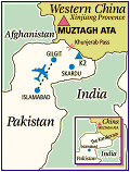 |
Muztagh
Ata means Father of Ice Mountains
in local language Kazakh and Uigur, both
are Turkish dialects. The massif of
Muztagh Ata lies in the Kunlun Shan range
on the high plateau in Western China,
where nomadic herders line and tend their
roving flocks. It is a huge
mountain-massive, which consists of two
summits, one of them is 7546m high and
other is 7130m. The distance between them
is 2 km. This program gives possibility to
ascent both summits from the same Base
Camp of Muztagh Ata. It takes 15-20 days
to main summit according to the
professional level of
|
|
participants.
It
is second highest peak in this range and
worlds easiest peak in above 7500
meters. Trek to the Base Camp sets us up
for the climb and allows us to experience
the diversity of the landscape and its
people.
|
BACKGROUND:
First
tries to climb Muztagh Ata were made in 1894 by
Swedish geographers Sven Hedin from the West. In
his two attempts he reached same altitude of
6300m. The first historic ascent of the Muztagh
Ata summit had been realized in 1956 by
Soviet-China expedition led by Eugene Beletsky
following the route outlined by Hedin. In 1980
an American group was allowed to climb and ski,
they broke world female record an altitude ski.
This is only ski peak in the world in 7500m.
Following them there were many expeditions from
all over the world is crowed with success so
far.
ROUTE:
The normal
route of Muztagh Ata from West, not difficult
technically and good for not competent
mountaineers, because of high altitude above the
sea level all along the route participants
should be well prepared. The climb is very
straightforward technically and suitable for the
skiers who want to combine skiing with trip high
altitude in the Himalayas. It is considered to
be the easiest peak in the world in 7500m peaks.
Alternative Muztagh Ata is superb place to
discover the world of high altitude climbing.
With summit reaching 7546m, this expedition is
excellent preparation for an 8000m-peak climb.
CAMPING:
The
Base camp is at the altitude of the about 4450m
and higher camps are set up normally around at
the altitude of about,
Camp-I
(5200m)
Camp-II
(6200m)
Camp-III
(6800m)
Duration:
28
to 30 days from Islamabad to back Islamabad
Time
Summary or Itinerary:
Day
01 03:
Arrival to Islamabad and transfer to
Day
04 05: Drive to Tashkurgan via Khunjerab
Pass and continue to
Karakul
Lake and trek to the Base Camp, overnight at
tents
Day
06-21
16-days for acclimatization and climb
Day
22-24:
Trek back to Karakul Lake and transfer to
Sost then to Karimabad
Day
25 27:
Transfer to Islamabad
Day
28:
Departure from Islamabad (drop to the
airport)
CLIMBING
EXPEDITION ON SPANTIK 2004/2005
NORTH
PAKISTAN is organizing an Expedition on Spantik
7027M Peak in 2004 that is named NORTH
PAKISTAN INTERNATIONAL SPANTIK 7027M EXPEDITION
2004. We offer all the climbers around the
world, who would like to join this expedition
and need to send the particulars at least before
the June and may have contact with us for more
details.
Route:
Normal Route
Duration:
31-days from Islamabad to back Islamabad
Meeting
of members:
At Islamabad at 25th July 2004
Type
of Expedition:
Unguided Expedition
Mode
of payment:
20%
should be transferred to our Bank account in
advance
to confirm the participation and the rest of
amount can be paid after your
arrival
to Islamabad before departing to the mountain
Terms
and Conditions: The
expedition will start from Islamabad and all
the
expedition members will join here and proceed to
the mountain all together
with
leader and while coming back from the Base Camp
all members should be
together,
if someone stays more in the Base Camp and if
someone wants to go
earlier
or latter to the Base Camp, should pay extra.
High Altitude food, tents,
climbing
equipments, high altitude porters and any
service beyond the Base
Camp
is NOT included in our services.
For
more details you may contact:
Tel:
0092-51-2535766
Cell:
0092-333-5276586
Fax: 0092-51-2855440
northpak@isb.comsats.net.pk
northpakistan@dsl.net.pk
ishaq_jan@yahoo.com
SPANTIK/7027M
BY NORMAL
ROUTE:
The
Spantik that is also called the Yengutz Peak is
the part of the mountain chain, which forms the
boundary between Hunza-Nager and Baltistan in
one of the quieter parts of the Karakoram. The
people from Hunza and Nager Valley called the
mountain GOLDEN PEAK/GOLDEN PILLAR form this
side. Viewed from Hunza-Karimabad, the sun
setting on Golden Pillar is a truly remarkable
sight. The ascend of the Pillar from this side,
difficult through North Pillar that is technical
route, first climbed by British mountaineers in
1987, was milestone in technical difficulty for
Himalayan Mountaineers.
The
other side (from Skardu-Balistan) of the
mountain is less daunting and offers a route to
the summit that more of climbers achieve. On
this side Spantik Peak is at the head of
CHOGOLUNGME GLACIER in Arandu Valley- Skardu. It
is usually climbed from Chogolungme Glacier (Arandu
side), via the relatively easy long South East
Ridge that is called NORMAL ROUTE.
Route:
The
climb a long the South East Ridge is the most
achievable route of any 700m Peak in the
Pakistani Karakoram. This route is generally
considered a safe and technically easy route and
has become the obvious target for commercially
organized expeditions looking for
straightforward ascent to 7000m. The ridge rises
2700m over its 8-Km length affording several
safe campsites. The climb through long and
arduous is not technically difficult. The
average gradient is 30 to 45 degree but there
some short steps that provide some climbing
interest. Spantik is a truly Himalayan scale
objective, an ideal next step for those who
previously climbed a 6000m peak or those
preparing for an 8000m expedition.
Background:
It
was first attempted in 1906 by the American
couple Fanny and William Bullock-Workman by this
route that reached up to the 6700m, a female
altitude record at that time. A German
expedition who made the first successful ascent
the mountain by this route in 1955 and repeated
several times since.
Approach:
Lying
to the south of the great Hispar Glacier and
standing above the remote upper Chogolungma
Glacier, Spantik offers an attractive climb. The
approach path starting from the Village of
ARANDU follows the beautiful ablution Valley a
long the side of the Choglungma Glacier, with
stunning vistas of mountain scenery with
innumerable high peaks all the way to Base Camp.
Arandu is connected to Skardu by jeep able road
and Skardu is administrative capital of
Baltistan and based for the expeditions for
several peaks.
Higher
Camps:
The
Base Camp is at the altitude of about 4300m and
higher camps are set up normally at about
altitude of
Camp-I
(5250m)
Camp-II
(5650m)
Camp-II
(6250m)
Climbing:
The
South East Ridge of Spantik is one of the most
attainable routes to a 7000m summit in the
Karakuram. From a rocky Base Camp (4300m) on the
edge of Chogolungma Glacier, the route follows
moderately angled snow slopes. The ridge goes up
2700m higher over its 8-Km length. The slopes
are mostly 30 degree less with a short section
of 40 degree. Base Camp is at the altitude of
4300m and Camp-I is located on a series of rocky
platforms close to snowline. From Base Camp-I
follows a moderately steep slope on grass then
high up changes to a scramble up rocky ridge
with platform loose screen. The route then
follows the long undulating ridge mostly on snow
to large level site of Camp-II (4-5hrs). Above
this slope steeped and 500-600m of rope normally
be fixed between Camp-II and III. The first
section of 400m will be fixed on open 35°
slopes leading to a large snow platform.
Sometime the climbers use this as a campsite.
After a few hundred meters there is easy ground
then slope of 40°
sections where 150m ropes will be fixed, before
reaching an obvious crest on the ridge. Here is
place of the Camp III (6250m), on a wide snow
ledge below the summit slopes and 4-5 hrs from
Camp-II. The route to summit from Camp-III is
quite straightforward. A gentle slope a height
of 6650 where it steepness to join the South
West Ridge. This is then follow for 400m at an
average angle of 30°
until it levels out 100m below the summit, where
will be equipped with fix rope. The top of
mountain is a rounded snow dome and 50m of rope
may be fixing on the short section leading onto
the summit slopes (6-8 hrs ascent 2-3 hrs
descent).
The
summit on clear days presents grand views of
neighboring mountains Rakaposhi 7788m and Diran
7258m as well as Ulter, Batura and Haramosh
peaks and in the distance the giant peaks of the
central Karakuram including Mt. K-2.
Time
Summary or itinerary:
We
start our trip from Islamabad to Skardu by road
on Karakuram Highway to Chilas (11-12 hrs drive)
then next day 7-8 hrs to Skardu. We have some
time to explore the town and enjoy the hustle
and bustle of many travelers purchasing supplies
and hiring porters. Our next destination is the
small village ARANDU, which is 85-Km Jeep
journey a long narrow mountain road. After
hiring the porters we will start the trek to the
Base Camp.
| 25th
26th July: |
Arrival to Islamabad, briefing at
the Ministry of
Tourism and formalities
|
| 27th
29th July:
|
Transfers to Skardu, shopping and
preparation
|
| 30th
2nd August: |
Transfers to the Base Camp, the approach to the Base Camp
is about 304 days trek on Chogolungma Glacier
|
| 3rd
17th August:
|
The climbing and acclimatization
|
| 18th
23rd August: |
Return
to Islamabad via Skardu and formalities
at Islamabad |
| 24th
August:
|
Departure from Islamabad
|
Equipment
Note:
We
will provide only Base Camp equipment, you will
arrange high altitude equipment and also you
need to bring your own personal equipment
including ice axe, helmet, ascender (e.g. petzl
/jumar), descending deice (preferable a figure
of 80, crampons, rope, rucksack, climbing
harness, plastic mountaineering boots,
wind/waterproof cloths, sleeping bag,
mattresses, down/duvet Jacket, rain suit, warm
cloths and other personal necessary equipments
etc.
Physical
Fitness and Health:
To
participate this trip you must be very fit,
active trekker with climbing skill and in a good
health. Prior to joining this trip, please see
your doctor and obtain the necessary permission
and advice, as well as medications for travel in
extremes of altitude and also for exotic locals.
Make sure that you have physically trained
yourself very thoroughly before start this
climb. Malaria is found on the plains of
Pakistan, although it is not as common as in
wetter areas of the Pakistan. There is none of
the disease in the mountains, but you will still
need to take anti-malaria drugs. It is best to
assume all tap water and steam water is not safe
to drink. During the trek to and at the Base
camp you will get boil water to drink but you
may take the a variety of tablets or
alternatively take a small bottle of tincture of
iodine and put a couple of drops in each liter
of water you want to treat. The group would have
an extensive communal first kit.
Expedition
Member Experience:
Although
Spantik is an extremely easy and low angle
mountain, the member should have knowledge of
roped climbing techniques. It is also required
that all the members will have awareness of
altitude sickness, frostbite and recognition of
their symptoms, prevention and treatment.
Visa:
You
need a visa to enter the Pakistan. These can be
obtained relatively easily from a Pakistani
embassy or consulate in your country. You need a
single entry tourist visa
.
Tel:
0092-51-2535766
Cell:
0092-333-5276586
Fax: 0092-51-2855440
northpak@isb.comsats.net.pk
northpakistan@dsl.net.pk
ishaq_jan@yahoo.com
|